Published
- 28 min read
Where to Pan for Gold: 12 Best Spots (2026)
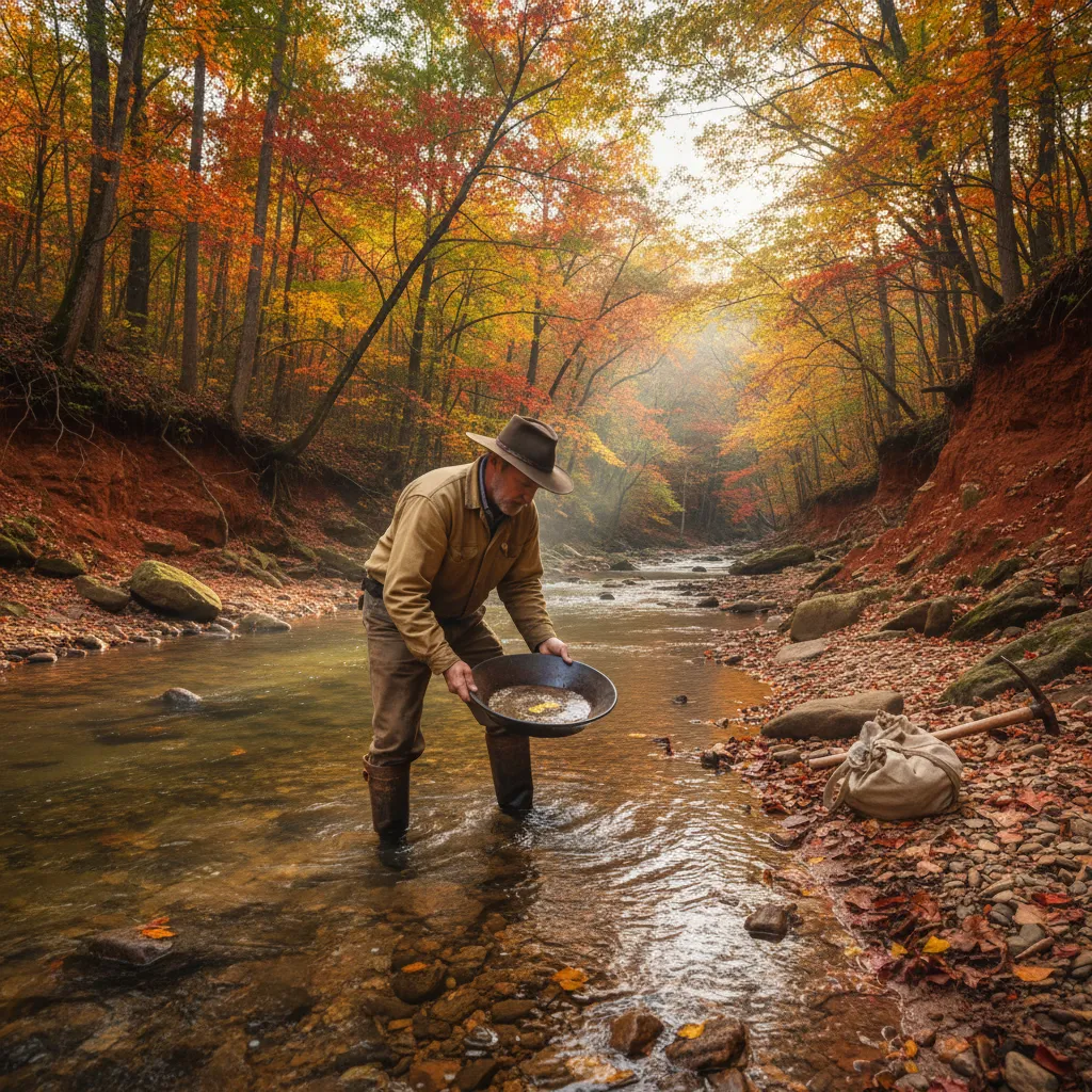
Every “where to pan for gold” article online is the same. They list states. They mention the Gold Rush. They tell you to “check local regulations.” None of them tell you where to actually park your truck and walk to the water.
I’ve been gold prospecting across America — California, Colorado, Arizona, Georgia, and a handful of other states. Some spots I’ve hit a dozen times. Some I’ve visited once and keep meaning to get back to. Below are the best gold prospecting locations in the USA that I’d actually recommend to a friend — not states, not regions, actual places. Every recommendation is cross-checked against our interactive gold mine map, which I built from the USGS Mineral Resources Data System — a 74,805-site dataset covering 37 gold-producing states.
Quick answer — the best places to pan for gold in the US:
- Clear Creek at Idaho Springs, Colorado
- South Fork American River near Coloma, California
- Lynx Creek near Prescott, Arizona
- Chestatee River near Dahlonega, Georgia
- Animas River near Silverton, Colorado
- Nome Beach, Alaska
- South Platte drainage near Fairplay, Colorado
- Woods Creek near Jamestown, California
- Orofino Creek, Idaho
- Josephine Creek, Oregon
- Reed Gold Mine area, North Carolina
- Libby Creek, Montana
Where to Pan for Gold in the United States
The United States has documented gold deposits in over 40 states, but not every state offers practical recreational panning. The spots below combine accessible public land, documented gold production, and realistic chances of finding color. I’ve prioritized locations where you can show up, pan legally, and expect to see gold — not just theoretically, but consistently.
Colorado — Rocky Mountain Placer Gold
Colorado is my home turf and where I do most of my prospecting. The USGS logs 6,088 gold-bearing sites statewide — 401 current producers, 4,084 past producers, and over 1,100 prospects and occurrences — concentrated along the Front Range and in the San Juan Mountains. The Clear Creek drainage alone accounts for over 60 of those mines. I wrote a full guide to gold panning in Colorado if you want the deep dive, but here are the highlights.
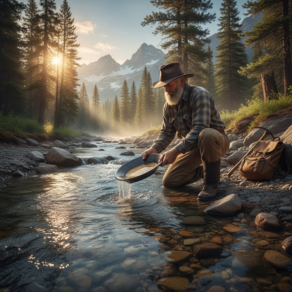
Clear Creek at Idaho Springs is my home creek. I’ve lost count of how many times I’ve been here — forty? fifty? — and I still find gold every single trip. That consistency is rare.
Park near the Welcome Center on Highway 6, the one with the mural of the miner on the wall. Walk upstream past the footbridge, maybe a quarter mile, until you start seeing exposed bedrock along the inside bends. That’s where you start digging.
The gold is fine. You need a snuffer bottle — I use a Pro-Line, the ones with the wider opening, after going through two garbage Amazon snuffer bottles that either wouldn’t squeeze right or had tips too narrow to pick up anything. The Pro-Line was like eight bucks and it just works. Bring a Garrett 14-inch green pan if you don’t already own one. Twelve dollars. You don’t need anything fancier. For a full breakdown of what gear is actually worth buying, check my gold panning equipment guide.
My best day here was last September. I’d walked past this one bedrock crevice probably a dozen times over the years — unremarkable looking, maybe two inches wide, running diagonal to the current. Something made me stop and clean it out with a screwdriver. Three pans, about 0.3 grams total. Not retirement money, but chunky for Clear Creek. I was so focused on that crevice I didn’t notice the thunderstorm rolling in until rain was already running down my neck. Drove home in wet jeans, grinning the whole way. My buddy Marcus, who grew up in Fairplay and has been prospecting since he was a kid, says I’m “the only person who gets excited about a third of a gram.” He’s probably right but I don’t care.
The one downside is weekends in summer. Clear Creek gets crowded. Families tubing, people walking dogs, other prospectors shoulder-to-shoulder at the obvious spots. I go in September when the crowds thin out and the water drops. Lower water means you can work bedrock that was submerged all summer. That September window between Labor Day and the first real cold snap is the best prospecting in Colorado, full stop.
Neoprene gloves are mandatory, by the way. Not optional, mandatory. The water comes straight off the Continental Divide and it will shut your hands down in fifteen minutes bare. Get 3mm dive gloves. They’re cheap and they’re the difference between a full day of panning and giving up by noon.
Animas River near Silverton is where you go for the adventure. The Silverton-Ouray mining district has over 150 documented mines in the database — one of the densest gold-producing areas in the entire West. The drive over Red Mountain Pass is worth the trip on its own — hairpin turns with thousand-foot drops and no guardrails, which is either thrilling or terrifying depending on how you feel about heights. I white-knuckled it the first time. Now I barely notice. That might not be a good sign.
The Animas between Silverton and Howardsville has some of the coarsest placer gold in Colorado. I’ve found pieces here that were actually chunky — not quite nuggets, but bigger than anything Clear Creek has ever given me. The trade-off is that you work for it. The elevation is above 9,000 feet, the water will numb your hands in ten minutes even with neoprene gloves, and afternoon thunderstorms show up like clockwork starting around 2 PM.
Check for active mining claims before you set up. They’re scattered throughout the drainage, and at last filter on the mine map the Silverton–Ouray polygon shows dozens of past-producer and prospect sites mixed with a handful of current producers — meaning live claims are realistic. Getting confronted by a claim holder is not how you want to spend your afternoon. I plotted thousands of claims and mine locations from USGS MRDS and BLM LR2000 records, so you can filter by claim status before you drive.
Beaver Creek near Fairplay — about ninety minutes from Denver, with over 90 documented mines in the surrounding South Park district. Less crowded than Clear Creek, and the gold tends to be a bit coarser. Marcus (the Fairplay native I mentioned earlier) told me the old-timers called Tarryall Creek “Grab-all” because the early miners were so possessive of their claims. I have no idea if that’s true but it’s a great story and I choose to believe it.
California — The Gold Rush State
California needs no introduction. The USGS logs 23,872 gold-bearing sites in California — more than any other state by a 3x margin, including 1,444 current producers and 8,813 past producers — and the Mother Lode belt running through the Sierra Nevada foothills is still producing placer gold 175 years after the Rush.
I’m not going to repeat everything from my California gold article — I go deep on the Mother Lode there. But two spots belong on any list of where to pan for gold in the US.
South Fork American River near Coloma is where James Marshall found that first flake in 1848. The surrounding El Dorado County district has over 100 mines in the USGS records. The stretch between Lotus and Salmon Falls has BLM land with public access. The inside bends have exposed bedrock with crevices that trap gold year after year.
Bring a crevicing tool. The bedrock has deep cracks running perpendicular to the current. Surface panning gets you flour gold; cleaning out crevices is where the real flakes are. One thing the YouTube videos don’t mention — the gold concentrates at the bedrock contact, that layer where loose gravel sits directly on top of solid rock. Dig down to that contact zone and pan that material specifically. It’s heavier and dirtier than the surface stuff, but that’s where the gold lives.
Woods Creek near Jamestown is legendary — over 60 mines cluster within the Jamestown district alone. Miners pulled fist-sized chunks during the Rush. Those are gone, but the old tailings piles still hold gold the original miners missed. Their extraction methods were crude by modern standards. Bring a classifier and work that tailings material — the forty-niners didn’t have classifiers and they left gold behind.
Best time to visit: Late spring through early fall. Water levels in the Sierra rivers drop through summer, exposing more bedrock to work. Avoid peak summer weekends at Coloma — it’s a state park and a tourist attraction, so it gets packed.
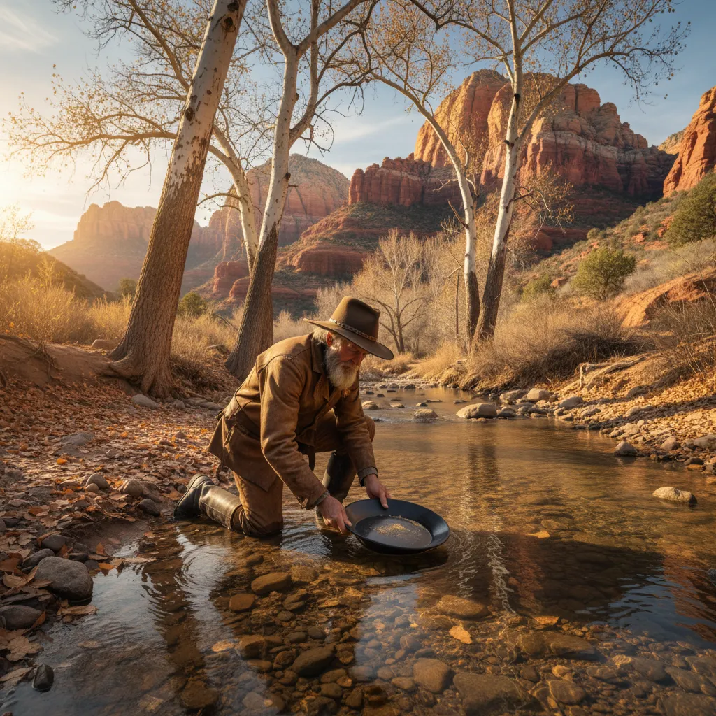
Arizona — Desert Gold Year-Round
Arizona is my winter escape. When Colorado is buried under three feet of snow and I’m losing my mind, I drive south. The USGS logs 5,051 gold-bearing sites statewide — 687 current producers (one of the highest active counts in the country) and 2,732 past producers — heavily concentrated in Yavapai County around Prescott. That high producer count matters: it means Arizona has more active claims per square mile than most western states, so claim-checking on the mine map is non-negotiable before you set up. I put together a complete Arizona gold panning guide covering the Bradshaw Mountains, Lynx Creek, and the best desert prospecting spots.
Lynx Creek near Prescott is the crown jewel for recreational panners, with over 80 documented mines in the Prescott area alone. The Prescott National Forest maintains a designated gold panning area along Lynx Creek about 8 miles east of Prescott on Walker Road. Small parking area, clear signage, year-round access. It’s one of the few spots where the government essentially said “yes, come pan here, we’re fine with it.” If you’re wondering where else that applies, I put together a breakdown of gold panning laws by state — the rules vary way more than you’d think.
I went down for a weekend in January a couple years back. Fifty degrees, clear sky, creek running clean. Color on my second pan. A couple flakes, nothing dramatic. But I was standing in a creek in January in a t-shirt while my neighbors back in Colorado were shoveling their driveways. Hard to complain.
The gold sits right on top of the clay layer. Work the inside bends, dig down until you hit clay, and pan that contact zone. That’s where everything concentrates. This is the same principle you’ll use at any gold-bearing creek — gold is 19 times heavier than water, so it sinks through lighter material and stops at the first hard layer, whether that’s bedrock or compacted clay.
One thing about Arizona creeks that nobody tells you: watch where you step. I nearly put my foot on a rattlesnake sunning itself on the trail down to the creek. March. It was probably more scared than I was, but I’m genuinely not sure about that. My heart rate didn’t come down for about an hour.
Rich Hill near Congress, Arizona is worth mentioning too. Famous for producing gold nuggets — some of the richest placer deposits ever found in Arizona. The area is heavily claimed now, but BLM land surrounds many of the historic workings. Check claim status carefully before you dig. Rich Hill is one of those spots where metal detecting for gold can be more productive than panning, since the gold tends to be coarser and nuggets still turn up. If you want to combine detecting with exploring old mine sites specifically, the guide to metal detecting around old mines covers what to look for and how to stay safe doing it.
Best season: October through April. Summer temperatures in central Arizona regularly hit 110°F. Don’t be a hero. I made the mistake of visiting Lynx Creek in July once and lasted about two hours before the heat drove me back to my truck.
Georgia and North Carolina — East Coast Gold Belt
Here’s my borderline-controversial opinion: for the average recreational prospector who doesn’t want to fly to California, the Appalachian gold belt is criminally underrated. Georgia, the Carolinas, even Virginia have documented placer deposits and basically zero competition. I think more people should be looking east instead of west and I’ll die on that hill.
Dahlonega, Georgia — Most people don’t know America’s first gold rush happened here. Twenty years before California. The USGS logs 503 gold-bearing sites statewide in Georgia — only 1 current producer but 297 past producers and 178 prospects — with Lumpkin County alone holding over 70 of those records. Almost zero active claim conflict means recreational panners have the place to themselves. The town’s name comes from the Cherokee word for “yellow.” And yet I’ve never once seen it on a major prospecting “top 10” list, which drives me a little crazy. I wrote a full guide to gold panning in Georgia covering Dahlonega and the surrounding area.
I drove down from Nashville one Saturday in October — about four hours through the kind of rural Georgia that makes you wonder if your GPS is lying to you. There was a stretch on Highway 52 where I didn’t pass another car for twenty minutes and the road got narrow enough that I was watching for deer in both lanes. Parked at a pulloff near the Chestatee River and hiked down to the water in my Chacos, which was stupid. The banks are slippery red clay that will send you sliding on your butt if you’re not wearing actual shoes. I know this because it happened.
Colors on my first pan. Extremely fine gold, finer than what I find in Arizona or Colorado. Your panning technique needs to be dialed in or you’ll wash it right over the rim without ever seeing it. The red Georgia clay will clog your classifier — break it up by hand in the water before you try screening. And the humidity — bring water, bug spray, and low expectations for your comfort level. I’ve prospected in August Arizona heat and I still think Georgia humidity is worse.
On the Chestatee that Saturday I didn’t see a single other person with a pan. In California you’re fighting for elbow room.
North Carolina has its own gold history that predates even Georgia. The first documented gold find in the US happened at Reed Gold Mine in Cabarrus County in 1799 — a 17-pound nugget that the Reed family used as a doorstop for years before figuring out what it was. The USGS logs 591 gold-bearing sites in North Carolina — 65 current producers and 401 past producers — with over 30 clustering in the Cabarrus-Stanly corridor alone, mostly running along the Carolina Slate Belt from the Virginia border down through Charlotte. I cover the best access points and regulations in my North Carolina gold panning guide.
The Uwharrie National Forest offers some of the best public-land panning on the East Coast. The gold is fine — similar to what you’ll find in Georgia — but the forest setting and lack of crowds make it worth the trip. If you’re anywhere in the southeastern US and think you have to fly to Colorado or California to find gold, you don’t. Start here.
Alaska — Remote Frontier Gold
I haven’t been. I’m putting it on this list anyway because everyone who has been tells me it’s unlike anything else — gold on the beach, no claims needed, no permits, just sand and a pan and the Bering Sea wind trying to freeze your face off.
Nome Beach is the classic destination. Gold washes onto the beach from offshore deposits, and you can legally pan the intertidal zone without any permits or claims. The USGS logs 8,177 gold-bearing sites in Alaska — 294 current producers, 2,859 past producers, and an unusually high 3,183 prospects, which is the largest pool of unworked ground in the country — and over 40 of them cluster along the Seward Peninsula near Nome. This is one of the few places in the country where you can pan for gold for free with absolutely zero paperwork.
Go in late July or August. Bring your own equipment because there’s no prospecting supply store in Nome. Ship heavy gear ahead if you can. And bring layers — the Bering Sea coast in summer is still cold enough to make Colorado mountain water feel warm.
Fairbanks area is the other major Alaska destination. The Chatanika River and Pedro Creek have public access points with documented gold. The interior is warmer than the coast, and the gold tends to be coarser. But getting there requires more planning than most Lower 48 trips.
Idaho — Public Land Paradise
Idaho doesn’t make most gold prospecting lists, which is exactly why it interests me. The USGS logs 4,468 gold-bearing sites in Idaho — 166 current producers, 1,880 past producers, and 942 prospects — primarily in the Boise Basin and along the Salmon River drainage. Massive amounts of BLM and National Forest land mean access isn’t an issue.
Orofino Creek in Clearwater County was the site of Idaho’s first gold rush in 1860. Over 50 mines are documented in the Clearwater drainage alone. The area around Pierce and Orofino still produces placer gold, and the creeks drain through National Forest land with generous public access. I haven’t been here yet — it’s on my short list — but the mine density on the interactive mine map for this area is remarkable. Clusters of historic mines along nearly every tributary.
The Boise Basin around Idaho City was one of the richest placer districts in the West. Mores Creek and Grimes Creek both have public access points and documented gold. The terrain is lower elevation than most Colorado spots, which means a longer panning season and warmer water.
Oregon — Beach and River Gold
Oregon offers something unique: beach gold. The USGS logs 4,829 gold-bearing sites in Oregon — 333 current producers, 1,572 past producers, and over 2,600 prospects and occurrences — and storms wash gold-bearing black sand onto beaches along the southern coast, particularly near Gold Beach (the name isn’t subtle) and Port Orford.
Josephine Creek in the Rogue River drainage has over 200 documented mines in the surrounding district. The Illinois River area, particularly around the old Briggs Creek mining district, has public-land access with fine to medium placer gold.
The southern Oregon beaches are where things get interesting. You can legally pan the black sand deposits along public beaches. The gold is extremely fine — flour gold, mostly — but it’s there, and the experience of panning on a Pacific beach with sea stacks in the background is hard to beat.
Montana — Sapphire Country Gold
Montana’s gold history goes back to the 1860s, with major rushes at Bannack, Virginia City, and Last Chance Gulch (now Helena). The USGS logs 4,769 gold-bearing sites in Montana — 216 current producers, 2,297 past producers, and 708 prospects — and the state offers excellent public land access.
Libby Creek near Libby, Montana has a designated recreational gold panning area maintained by the Kootenai National Forest, with over 25 mines documented in the surrounding Lincoln County. Free permit, clear boundaries, and documented gold. It’s one of the most beginner-friendly spots in the Northern Rockies — if you’ve never panned before and want a low-pressure first experience, this is hard to beat.
Grasshopper Creek near Bannack State Park — where Montana’s first gold rush started in 1862 — still produces color. The state park has interpretive displays about the rush, and nearby public land offers panning access.
Gold Prospecting Locations at a Glance
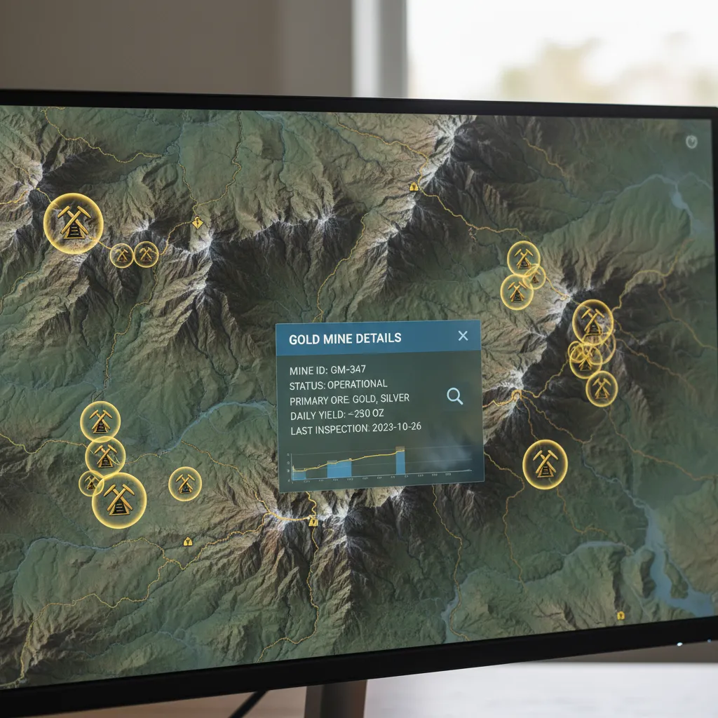
I pulled these numbers from the GoldFever.app database, which compiles mine records from USGS and state geological surveys. The full dataset covers 74,805 mines across every state — far more than just gold, but the gold-specific numbers below tell you where the geology is favorable. More mines doesn’t automatically mean better panning — some areas have concentrated, accessible deposits while others are spread across remote wilderness — but mine density is a solid starting indicator.
| Location | State | Mines in Area | Best Season |
|---|---|---|---|
| Clear Creek, Idaho Springs | Colorado | 60+ | June – September |
| South Fork American River, Coloma | California | 100+ | May – October |
| Lynx Creek, Prescott | Arizona | 80+ | October – April |
| Chestatee River, Dahlonega | Georgia | 70+ | March – November |
| Animas River, Silverton | Colorado | 150+ | July – September |
| Nome Beach | Alaska | 40+ | July – August |
| Beaver Creek, Fairplay | Colorado | 90+ | June – September |
| Woods Creek, Jamestown | California | 60+ | May – October |
| Orofino Creek | Idaho | 50+ | May – October |
| Josephine Creek | Oregon | 200+ | June – September |
| Reed Gold Mine area | North Carolina | 30+ | April – October |
| Libby Creek | Montana | 25+ | June – September |
Want to explore the data yourself? Open the GoldFever.app mine map and zoom into any area. You can filter by mineral type and see exactly where historic mines cluster.
How to Find Your Own Gold Panning Spots
All the locations above answer the question of where to pan for gold if you want proven spots. But what if you want to find gold panning spots near you that aren’t on any list? The spots nobody writes about are the ones I find most interesting — little creeks on BLM land near clusters of historic mines that don’t show up on any “top 10” list because they’re too small or obscure.
Where Gold Concentrates in Rivers
Understanding how gold moves in rivers will help you more than any location list ever could. Gold is 19 times heavier than water, so it behaves differently than everything else in a streambed:
- Inside bends — Water slows on the inside of curves, dropping heavy material. This is your first stop at any new creek.
- Behind large boulders — Gold settles in the low-pressure zone downstream of big rocks. Dig as deep as you can behind them.
- Bedrock crevices — Gold sinks into cracks in exposed bedrock and stays there, sometimes for centuries. A screwdriver or crevicing tool is essential.
- Bedrock contact zone — The layer where loose gravel meets solid bedrock underneath. Most experienced prospectors dig straight down to this layer and ignore everything above it.
These aren’t theoretical. Every spot I recommended above produces gold at these exact features. Learn to read a creek and you can find gold at places nobody has written about.
Reading USGS Geological Maps
The USGS publishes geological maps showing rock types, fault lines, and mineral occurrences. Gold deposits form where specific conditions align — usually where quartz veins intersect fault zones in metamorphic or igneous rock. You don’t need a geology degree to use this:
- Look for areas mapped as “metamorphic” or “volcanic” rock — these are your target zones
- Find fault lines that cut through those rock types — faults create pathways for gold-bearing fluids
- Cross-reference with historic mine locations — if there are abandoned gold mines in the area, the geology is favorable
- Check downstream waterways — gold erodes from hard-rock deposits and concentrates in streams below them
Using Historic Mine Data to Find New Spots
This is where the interactive mine map becomes genuinely useful beyond just browsing. Here’s my process:
- Zoom into a region you’re planning to visit
- Look for mine clusters — three or more mines close together mean the geology consistently produces gold in that area
- Cross-reference with public land — BLM and National Forest land is generally open for recreational panning
- Find the downstream creek — Gold doesn’t stay at the mine. It washes downhill into the nearest waterway. A creek running through or below a cluster of historic mines has been collecting gold for decades or centuries
- Check for access — A forest road, trailhead, or pulloff near the creek means you can actually get there
Some of my best days have been at spots I found this way — places where I drove down a forest road, parked at a random pullout, and hiked to a creek that turned out to have color. Nobody was there. Nobody wrote about it. It was just mine data plus public land plus a willingness to explore.
Gold Panning Laws and Permits by State
Do you need a permit to pan for gold? Knowing where to pan for gold is only half the puzzle — you also need to know where it’s legal. In many cases, no permit is needed. But the rules vary dramatically by state and land type. I put together a comprehensive breakdown of gold panning laws by state — it’s one of my most-referenced articles because the regulations are genuinely confusing.
The short version:
- BLM and National Forest land generally allow recreational gold panning with hand tools (pan, shovel, classifier) without a permit. No motorized equipment, no suction dredges, no sluice boxes in many states.
- State parks usually prohibit or restrict mineral collection. Don’t assume you can pan just because there’s a creek.
- Active mining claims are private property for mineral rights, even on public land. Panning someone else’s claim is illegal. Check claim status before you dig.
- Where you can pan for gold for free: BLM land in western states is your best bet. Alaska beaches, Arizona’s designated panning areas, and many National Forest streams allow free recreational panning with no permit required.
States where panning is particularly straightforward: Alaska (beaches are wide open), Arizona (designated areas like Lynx Creek), Colorado (most public waterways), Idaho (generous BLM access), and Montana (designated recreational areas).
States with more restrictions: California (seasonal dredging bans, some county-level rules), Oregon (waterway-specific restrictions), Georgia (less public land, more private property considerations).
When in doubt, check with the local BLM field office or ranger station. I’ve never had a ranger be anything but helpful when I’ve asked.
Related State Guides
Each of the five states I prospect most has its own deep guide with creek-by-creek breakdowns, county-level USGS mine counts, regulations, and the best access points. If you’ve narrowed down where you want to go, start here:
- Gold Panning in California — 23,872 USGS gold sites; Mother Lode districts, Sierra foothill rivers, and dredging regulation updates.
- Gold Panning in Colorado — 6,088 USGS gold sites; Clear Creek, the South Platte drainage, San Juan placers, and Front Range access points.
- Gold Panning in Arizona — 5,051 USGS gold sites; Lynx Creek’s designated panning area, Rich Hill nuggets, and winter desert routes.
- Gold Panning in Georgia — 503 USGS gold sites; the Dahlonega belt, Chestatee River access, and the original 1828 rush sites.
- Gold Panning in North Carolina — 591 USGS gold sites; Reed Gold Mine, the Carolina Slate Belt, and Uwharrie National Forest panning.
If your state isn’t above, the where is gold found in the United States overview maps the full 74,805-site dataset by region — including states without dedicated guides yet like Nevada, Oregon, Montana, Idaho, and Alaska.
Essential Gold Panning Equipment
You don’t need much. Here’s what’s actually worth buying versus what’s marketing:
The basics (~$30 total):
- 14-inch gold pan (Garrett green, ~$12)
- Classifier/screen (~$10)
- Snuffer bottle (~$8)
- Glass vial for gold
Worth adding later:
- Crevicing tools (a screwdriver set works fine)
- Neoprene gloves (3mm, ~$15 — mandatory for mountain creeks)
- A classifier set with multiple mesh sizes
I wasted money on gear I didn’t need when I started. Here’s my honest equipment guide so you don’t repeat my mistakes. Once you outgrow the pan, a sluice box is the natural next step — it lets you process ten times the material in the same amount of time.
The gold panning process itself is straightforward: collect material from a promising spot, submerge it, shake the pan to let heavy gold sink to the bottom, and carefully wash away the lighter material. Gold catches behind the riffles in your pan. When you see black sand concentrating, slow down — gold hides in and around that black sand. A full technique walkthrough will get you up to speed in an afternoon of practice. Once you’re comfortable with a pan and want to scale up — sluice boxes, highbankers, dry washing — the complete guide to gold mining techniques covers what comes next.
What to Realistically Expect
Can you really find gold panning? Yes. I find gold on the majority of my outings at the spots listed above. But let me be honest about what “finding gold” actually means for recreational panning.
On a typical good day, I’ll recover 0.1 to 0.3 grams of fine gold. At current gold prices (~$2,900/oz as of early 2026), that’s roughly $9 to $28 worth of gold for a full day of work. My best single day was maybe 0.5 grams. I’ve heard of recreational panners pulling a gram or more from rich spots, but I’ve never personally done it.
You’re not going to get rich. That ten-dollar gold pan? It’s a great investment — for a hobby. Think of it like fishing. Nobody expects to offset the cost of their boat with the fish they catch. The value is the experience: standing in a creek, solving the puzzle of where gold hides, and occasionally seeing that unmistakable yellow flash at the bottom of your pan. Make sure you know how to tell real gold from pyrite before you get too excited about that first sparkle, though.
What state is easiest to find gold? If you’re still wondering where to pan for gold as a complete beginner, I’d say Arizona in winter or Colorado in summer. Both have designated panning areas with documented gold, straightforward access, and enough other prospectors around that you can learn by watching. Alaska technically has the most accessible gold (Nome Beach), but the logistics of getting there make it a poor first trip.
Manage your expectations but don’t zero them out. I’ve put a pan in water at locations where forums said “the gold is gone” and found color anyway. Geology is patient. Rivers keep concentrating gold. The old-timers missed plenty.
Explore 74,805 Mine Locations on the Map
Every spot I’ve recommended in this article came from the same process: studying mine data, checking public land boundaries, and going to look. I built the GoldFever.app mine map to make that process easier for everyone.
The map plots all 74,805 USGS-documented gold sites across the United States, compiled from the USGS Mineral Resources Data System, state geological surveys, and BLM mining records. Zoom into any area, filter by producer / past-producer / prospect status, and start planning your own trips. Find abandoned gold mines near you or explore where gold is found across the entire United States — the database covers every major gold-producing state.
But honestly? You can read lists like this forever. I spent months researching before I put a pan in water. Just pick the closest spot, drive there Saturday, and get your hands cold. You’ll figure out the rest.